Good times at snowshoe - hittin the road gap:
Saturday, August 27, 2011
Thursday, August 25, 2011
Monday, June 13, 2011
A new adventure ... our new (rental) house


To the right is a photo of the living room/den as you enter the front door. As you will see in all of these photos, we're still moving in, so things are a little cluttered. The door to the left in the photo is to a half bath (we have 1.5 baths in the house, the extra .5 is very nice to have).
Below are some other photos of different vantage points from the living room.


From the living room, you can go into the dining room/study. The photo on the top is the view from the dining room/study to the kitchen.


From the kitchen you cross through a hallway to the laundry room/Joshs work bench:


Below is a picture of the kitchen:

Upstairs: First going up the stairs, notice the bathroom door at the top of the stairs (with the yellow paint) and the photo on the right is once you are up the stairs, facing to the left.


The bathroom:


The guest bedroom: (through the door in the photo on the left is a porch that is accessible from both bedrooms)


And finally the master bedroom (I am totally frustrated with the green carpet upstairs, I mean green carpet and green walls ... I like green, but am also into the idea of complementing colors).


And the mutant closet in the master bedroom. The folks who built this place realized that closet space was at a premium. (I mean who creates the closet to the left? That's a photo of the closet in the dining room/office thats near the front door. There's only space in there to hang like 2 coats!)


Saturday, June 4, 2011
Fruita - Cross Country in the Beautiful Pollen Meadow of Death
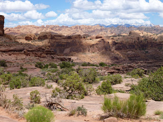
We left Moab after a great breakfast and drove up the Colorado River to I-70 which took us to Fruita, CO. We visited the 18 Rd. area which is an interesting and oddly beautiful desert area with soft colors that mix together well - purple and green fields, darker green shrubs and light beige soil. While I haven't used my SLR camera much lately I pulled it out here and took this picture, which really works for me - one of the best I've taken in a while, I think. I like the colors and the mountains fading off in the distance. It was a cloudy hazy day that for once seems to work in the picture's favor.


 |
| North Fruita Desert - click for larger pic. |
The riding in the 18 Rd. area was only so-so - would have definitely enjoyed it much more on a hardtail since its very smooth. However, there was one standout trail called Zippity-Do-Da which had some really steep ups and downs and felt a lot like a roller coaster. Joe's Ridge was also fun, but I wouldn't recommend much else.

Some other shots:


For the most part, I though Fruita 18 Rd. was not much more than an interesting novelty as far as riding there was concerned. I think Fruita realized I felt this way, because the next day, the sun came out, the wind picked up, and that meadow I thought was so pretty started outputting pollen like nobody's business. We were on our way out anyway, but all the sneezing and eye-watering made sure we got going quick.
Friday, June 3, 2011
In Moab, UT
So by this time, we still had not had showers (just an update ...). On to more "important" things: as Josh reported, we had an awesome time on our first ride in Moab. The sun went under the clouds for a good bit of the ride (there were NO trees on the 13ish mile ride) so that the temperature didnt get too bad. And the views were just some of the best I have ever seen. The pictures Josh posted doesnt even do it justice. Different terrain, lots to see. The Amasa Back trail was a lot of fun because there was a lot of chunky rock to go over. We'll post a video later that gives you a good idea of what was so fun about this trail (other than the weather and the great views).
SO, the next day ... we woke up at 630 (which really was a trend for this vacation, given the 2 hour time difference, we rarely woke up later than 730) and headed to town for breakfast. After fueled, we got our stuff together for our shuttle up to the top of Kokopelli's Trail, a part of the trail fondly called "the whole enchilada." You see, there is this trail in moab called the whole enchilada that drops 7,000 feet (starting at like 11,000 feet down to 4,000 feet) in over 30 miles of (mostly) downhill. Because the snow hasn't completely melted above about 9,000 feet in elevation, we couldn't do the whole thing. Instead we had to "settle" for only 4,000 feet in decent over about 20 miles. Heres a photo of Josh at the start of our trip (at about 9 am in the morning).
 Notice the trees and vegetation behind Josh.
 And the snow capped peaks here in the background. As we descended into the desert, we encountered slickrock on the trail. At one point in time, I found myself descending down slickrock at about a 65 degree angle into some rocks. During the moment, I remember thinking, this isnt going to work out well. I got back to level ground, I grunted and ended up landing on the top tube of my bike instead of my seat enough to widen my eyes, but not hard enough to draw tears, quite an accomplishment. This was the beginning of my realization that either I was better at biking than I thought or the trail wasnt as hard as I thought. After gaining some confidence, this trail was just pure fun for the rest of the trip (minus the occasional uphill, of which there was definitely too many for our taste).
My favorite part of the trail concluded with whats called the "diving board:" a rock that juts out kind of like a diving board, which you (and in our case, Josh, can jump off of). While not the diving board, heres a great action shot of Josh.
 So from here things got a little more desert like.
 By the time we finished, we were starting to feel tired. 21 miles (mostly) downhill and then when we were done we had about a 3 mile bike ride into town to our car (which was parked at the bike shop that shuttled us to the top).
After about 5 hours of biking, we reached our car and changed clothes. At one point in time during this change of attire, we both found ourselves sitting in our car (note: fully dressed, no mid-changing zoning out happened) as it sat in the parking lot, we alternated between staring idly and checking email on our phones, kind of zombie like.
Dressed and ready for the second part of our day, we found ourselves at a pizza, salad and soup all you can eat buffet deal in downtown Moab, where we attempted to eat as much as we possibly could (trying to eat dinner and lunch at the same time). After successfully stuffing ourselves, we headed to Negro Bill's Canyon (yes, thats what they call it) to hike to the Morning Glory Bridge.
 A natural bridge made out of rock (you can see it above the tree in the picture above). The destination of this 4.5 mile out and back hike was totally worth it ... HOWEVER, this was one of the longest hikes of my life. We were both "punchy" as we called it when we were little, so tired that everything was pretty funny. Not only was the tired-ness going on, but we were walking for about 1/2 of the time in sand that really gave your legs a work out. So, as you can imagine, we pretty much got back to our campsite (to which we had to hike about 4 mins, a long 4 mins that night!) and crashed!
SO, the next day ... we woke up at 630 (which really was a trend for this vacation, given the 2 hour time difference, we rarely woke up later than 730) and headed to town for breakfast. After fueled, we got our stuff together for our shuttle up to the top of Kokopelli's Trail, a part of the trail fondly called "the whole enchilada." You see, there is this trail in moab called the whole enchilada that drops 7,000 feet (starting at like 11,000 feet down to 4,000 feet) in over 30 miles of (mostly) downhill. Because the snow hasn't completely melted above about 9,000 feet in elevation, we couldn't do the whole thing. Instead we had to "settle" for only 4,000 feet in decent over about 20 miles. Heres a photo of Josh at the start of our trip (at about 9 am in the morning).


My favorite part of the trail concluded with whats called the "diving board:" a rock that juts out kind of like a diving board, which you (and in our case, Josh, can jump off of). While not the diving board, heres a great action shot of Josh.


After about 5 hours of biking, we reached our car and changed clothes. At one point in time during this change of attire, we both found ourselves sitting in our car (note: fully dressed, no mid-changing zoning out happened) as it sat in the parking lot, we alternated between staring idly and checking email on our phones, kind of zombie like.
Dressed and ready for the second part of our day, we found ourselves at a pizza, salad and soup all you can eat buffet deal in downtown Moab, where we attempted to eat as much as we possibly could (trying to eat dinner and lunch at the same time). After successfully stuffing ourselves, we headed to Negro Bill's Canyon (yes, thats what they call it) to hike to the Morning Glory Bridge.

Wednesday, June 1, 2011
Leaving Aspens, Entering Hot Sandstone...
Leaving off where Amanda did, we camped in Durango another night and decided to do an out and back ride on the Hermosa Creek trail which is supposedly a classic. It’s usually done as a shuttle but there’s still too much snow in the higher elevations. The trail was very smooth with frequent ups and downs, nothing very difficult skill-wise, but certainly tiresome. We made it out about 7 miles and then turned around and headed back for a 14-mile total ride.
Some pictures...


Some pictures...


On the trail, we met a very nice biker with her dog. Being the small world that it is, she turned out to also be a GIS professional and gave us awesome advice about Moab, UT – our next destination. Originally, we had planned to go to Fruita first, but a cold front came through, so we made the decision to head straight to Moab and ride one of the sunny ultra-hot slickrock trails (Amasa Back) in the cooler weather. This decision paid off tremendously and the next day was the best of the trip so far with incredible views and a great downhill with tons of rocks and jumps.


We chose the “Moses” option (akin to wandering through the desert for 40 years) and rode out to Pothole Arch which seemed lame when you first see it after riding all that way, but turned out to be pretty cool:


Following more of the great advice, we had a stellar camping spot (about a 100 yard walk into a canyon).

View from the campsite:


Moab is absolutely beautiful and unlike anything we’ve seen.
Josh
Monday, May 30, 2011
I got to wash my hair!
Amanda here, If you hadn’t figured that out from the title, since Josh is so concerned with the cleanliness of his hair. Yes, I got to wash my hair yesterday, after trying to find some water-less shampoo, I decided to just use a cup and our aquatainer and some shampoo of course. You see we have not had access to showers in over a week now ... on to more important things.
So picking up where Josh left off, below you will see what began as some minorly inconvenient snow drifts across the trail. 
And here you see about the elevation we got to and decided to turn around.
 The pictures don’t do the experience justice, but you get the idea.
So after hiking for 2 ish hours up and 45 minutes down, we decided to head to Durango, co, only to discover that our internet connection/joshs phone was on the fritz. After much deliberation we decided to just hope that the phone would restore itself and head on without a stop to Verizon (who weren’t much help on the phone by the way).
This was our home for the next couple days.  We got in at 930 Friday night of memorial day weekend and were somehow still able to get a camping spot in the free lower Hermosa campground. We woke up the next morning thinking we would get coffee and head on to fruita, co. At this point we had some idea that it was memorial day weekend. After packing up our camping gear and heading into town, we realized just what this meant … lots of people everywhere, which meant that trying to find camping in Fruita was going to be difficult, so after much deliberation (yes, it is becoming a theme of our trip), we decided to stay in durango til Memorial day let up. So, we caught up with email etc at the coffee shop, then went BACK to the campsite to find that our camping spot was still open, set up our tent and headed back into town. While walking around downtown Durango, we spotted this sign (link), a trials competition at a waterpark, how fun. This is a picture of one of the competitors.
  Trials is a kind of biking that Josh equated to climbing while we watched bikers jump from rock to rock. We hung out here for awhile, reading our trail map in the shade (its been really sunny for all of our trip). We realized that there was a short shuttleable downhill run nearby (Durango has soooo many mountain biking trails that you can even bike to from town!). So we drove out towards the Colorado trail and looked for a trail off of a forest service road. Josh rode the trail twice and then we headed to dinner. This place ended up being a favorite of ours.
Love, Josh and Amanda
Saturday, May 28, 2011
Colorado Trip 2011 - The first few fun days (Part 1)
Actually, the excitement started in Oklahoma when the skies got dark and we pulled into a gas station where a news station storm chasing team was frantically running around. We got a little concerned and got back on 40 - For the next hour, we listened to storm chasers broadcast on the radio spotting tornadoes forming and saying things like: "theres a lot of rotation here", "oh yea, this ones just formed and its going to cross I-40". Fortunately we learned we were driving away from the tornadoes and the next hour of listening to the broadcast was entertaining instead of frightening. If we had been 30 min or so later coming through there, we would have gone through some nasty stuff!
We made it to one of the best campgrounds in New Mexico (down in the Rio Grande gorge) that night around 11pm after 16 or so hours of driving:


We made it to one of the best campgrounds in New Mexico (down in the Rio Grande gorge) that night around 11pm after 16 or so hours of driving:

View from campsite:

We did a short hike the next morning and immediately saw some a group of 3 big horn sheep which tried to pose for a picture:

Enjoying the hike:

After that hike, we went into Taos and got advice from Taos Cyclery (dude there was super nice). For our intro to desert biking, we chose the Horsethief trail which has great views of the Rio Grande and some nice singletrack (with cacti to avoid riding over). We thought this was going to be a pretty short ride but it turned out to be a little longer than expected, especially with reading the map and navigating. After about 7 miles, we weren't quite sure where we were (which meant we didn't know if we had a few miles left or over 10). Amanda's response was "I'm going to kill you!" which then turned into "I'm going to kill that bike shop guy!". After that we figured out where we were and it wasn't too much further.
Start of trail:

One of many views:

Amanda riding:

Back at the campground:

The next day we headed into Carson Daly's Party Forest (also known as the Carson National Forest) southeast of Taos to ride the Woodpile trail (14 mile loop) which started around 8600' and topped out at 10,360'. This was up out of the desert which was nice since we definitely prefer trees. This was also a major navigational challenge with lots of second-guessing but ultimately we made it with only a few minor wrong turns. The bike shop guy said "slow" on this loop was about 3 hours, so I assumed it would take about 5 - it took 6 hours and 20 minutes. The trail was mainly doubletrack and the elevation made it difficult, but there were very pretty spots, and we saw more wildlife (1 brown bear, 2 assumed elk) than people (just us).

Yay trees!

Signs are very helpful in this forest:


Pretty aspen tunnels:

A nice meadow:

We camped that night down on the forest roads. The next day, we attempted a hike from 10,000' up to 12,400'. Everything was against us on this hike. Carson Daly's Top 40 map (Also known as the National Geographic Carson National Forest map last revised in '96) was COMPLETELY wrong about where the trail head was, which resulted in an hour of bush-whacking looking for it. We finally found it and started hiking up; I didn't waste much time before falling in a creek which my cell phone didn't seem to like too much. We kept going after that where we encountered a lot of knee-deep snow. After lots of "Well, lets just go another 30 minutes", we finally gave up around 11,300'. What was supposed to be a short morning hike took several hours and we didn't even make it to the top, but it was still fun. After that we drove 4 hours to Durango, ate some "Serious Texas Barbeque", and pulled into the camping area I knew of around 10pm where there was fortunately one spot left.
This morning (Saturday), we're at a coffee shop in Durango planning out the rest of the trip.
Josh
Subscribe to:
Comments (Atom)